
Residents of Bellevue Square public housing, 1974. photo: Hartford Housing Authority, Hartford History Collection, Hartford Public Library
By Fiona Vernal and James Kolb
(c) Connecticut Explored Inc., Fall 2022
Subscribe/Buy the Issue!
How did the North End of Hartford become a predominantly African American community in the mid-20th century and a bellwether for residential and racial segregation in the city? A common signpost is the opening of Bellevue Square in 1941, designed as a low-rent public housing project to accommodate 501 African American families, according to the 1940 – 1941 An- nual Report of the Hartford Housing Authority. Building footprints illustrated on Sanborn fire maps (see page 42) show a series of dumbbell-shaped buildings laid out between Bellevue, Canton, Wooster, and Pavilion streets. Hartford’s catastrophic floods of 1938, documented in more than 500 images from the U.S. Air Corps for the U.S. Engineer Office, had wiped out housing in the Windsor Street area where many African Americans lived and sent hundreds of displaced families into a capricious and unstable rental housing market.
Taken together, these two events—the historic flood and the opening of Hartford’s first African American public housing complex—offer a neat chronology of race and mobility in the North End. However, this confluence of events offers only one inflection point for understanding the history of African American mobility, enclosure, and residential segregation in the city of Hartford in the 20th century.
African Americans’ northward drift in the capital city began a full century before the Bellevue Square project. This chronology suggests a far more complex picture of residential segregation and the need to consider the longer arc of African American mobility and housing struggles alongside more familiar histories of redlining and residential segregation in the 20th century. The deep legacies of slavery and its visions of policing and containing free people of color in certain areas inform an understanding of how both de facto and de jure segregation chiseled residential segregation into American urban communities like Hartford. Nineteenth-century practices of de facto discrimination also played a role in predisposing African Americans to housing insecurity and calcifying deep pockets of generational precarity.
Commonplace, too, in the 19th century were everyday forms of discrimination in addition to more organized forms of racialized terror. For example, members of the Talcott Street Congregational Church, Hartford’s first African American church [See “Faith Congregational Church,” Summer 2005.], chafing at social norms that justified discrimination in sacred spaces, created their own religious society. Their contributions to the antislavery cause led to race riots and attacks on local African American homes in 1835, according to The Hartford Courant’s June 15 coverage. African Americans turned to familial and communal resources to confront these challenges, as Barbara Beeching has shown in Hopes and Expectations: The Origins of the Black Middle Class in Hartford (SUNY Press, 2017). Yet long into the 20th century, ingrained patterns of racial exclusion and overt and covert threats of violence continued to shape visions of their erasure and containment in certain areas.
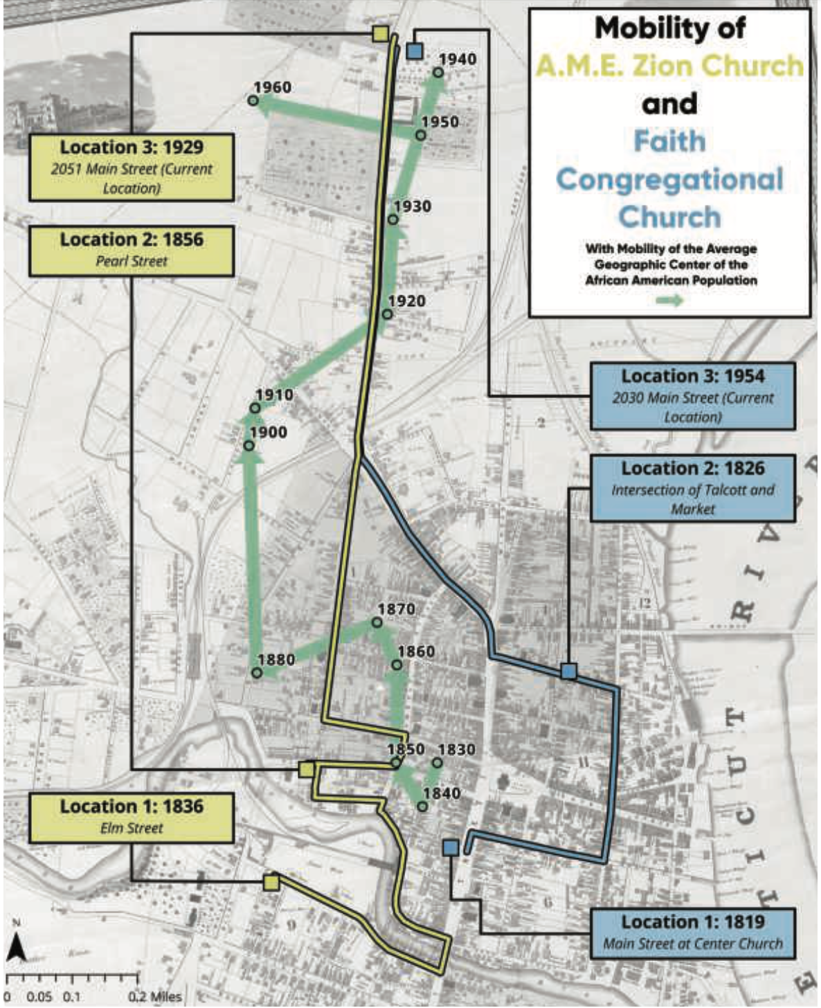
The yellow line shows the three locations of the Metropolitan A.M.E Zion Church, and the blue line shows the three locations of Faith Congregational Church. The churches followed, as shown by the green line, the northward drift of the African American population in Hartford beginning in the mid-19th century. By 1940 the population had settled in what would become Bellevue Square before expanding west across Keney Park. Hartford Bound, hartfordbound.com
The shifting boundaries of the city of Hartford delimited the spatial logics of these visions and practices. Hartford’s early African American neighborhoods developed in three clearly identifiable clusters in the city. In the older residential sections, near the Connecticut River, an initial cluster grew between the 1830s and 1860s. Many residences could be found on Front, Commerce, and Ferry streets, prime thoroughfares for the riverine traffic. Close to place of work, riverine and rail proximity were considered advantages long before the attendant environmental hazards and vulnerability to flooding were fully understood.
A second cluster, with its center near the Mill (or Park) River—a tributary of the Connecticut River—also developed between the 1830s and 1860s. It stretched from downtown into the southern reaches of the city. Here, people lived on streets like Cooper Lane and Bliss and Sheldon streets. A part of this community was displaced by the building of Bushnell Park during this period. A third cluster grew at Cemetery Lane (now Mather Street) in the proximity of Spring Grove Cemetery, the only cluster remaining after the 1960s. The siting of two of Hartford’s earliest African American churches, the Talcott Street Congregational Church and the African Methodist Episcopal Zion Church, in the clusters near downtown was a sign of how African American communities built their social and religious institutions in proximity to their residential locus.
The location of some of these neighborhood clusters duplicated vulnerabilities found in other American cities. Across the United States in the 19th century, African Americans lived close to flood-prone, poorly drained, swampy, or sloped areas, near municipal wastes, environmental nuisances, and cemeteries. Whether their communities formed a block, blocks, or streets, certain areas would become known as the Black part of town. Even when not explicitly set off as a “negro quarter,” or a “Black bottom,” African American enclaves like these became more discernible as race and space became more intertwined.
Despite the poor quality and limited supply of housing, Hartford’s promise of prosperity was a beacon for African Americans, near and far. The community that migrants joined hovered under 1,800 people in 1910, a number that reflected a particular contradiction. While many people came, still many others left, creating patterns of anemic growth and transience.
Some who sought opportunities in Hartford, including Catherine Murray from Fairfax, Virginia, had experienced enough of plantation life to set their sights elsewhere. Murray and 49 others from the same region of Virginia left for the usual New York gateway before trying secondary destinations. In doing so, Murray was participating in a long tradition of mobility and migration that had brought African Americans to other shores. Her “elsewhere” was Hartford, according to a profile by an unnamed Hartford Courant reporter on November 19, 1914. Despite a life of economic precarity, Murray remained a lifelong resident of Hartford, raising her daughter and her granddaughter in the city.
Other African American migrants tried their luck alongside the native-born population. As city directories document, they worked as shoemakers, bootblacks, laundresses, porters, waiters, laborers, cooks, janitors, and barbers. Some of the lucky ones had more singular business endeavors. Peter Lane, for example, went into pharmacy, followed by his sister-in-law Anna Louise James of the famed Petry family. [See “Searching for My James and Lane Families,” Fall 2019.] Augustus Washington, the successful daguerreotypist, like Lane, spent part of his life in New Jersey before coming to Hartford to open a studio in 1846. [See “Finding Freedom Through the Daguerreotype,” Fall 2021.] Renowned pianist and Kentucky native Raymond Lawson relocated to Hartford after graduating from Fisk University, according to a profile of Hartford’s African Americans that appeared in the May 1902 edition of The Colored American Magazine, “Hartford, CT: Sketches of Some of Her Prominent Citizens.” Grant Williams, the author of this profile, was also one of these highly mobile people willing to plant his freedom dreams in as many places as possible.
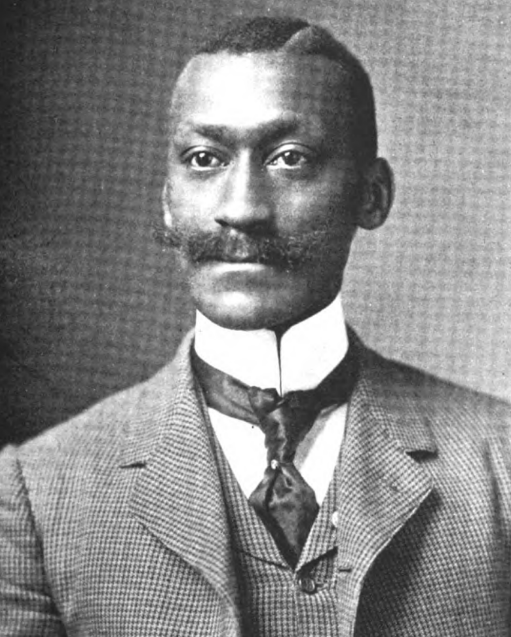
George Grant Williams. Colored American Magazine, May 1902.
Grant Williams described himself as “a general agent for high class Negro Literature,” in an ad he placed in Geer’s Hartford City Directory in 1895. He made his sojourn to Hartford in the 1890s. Alongside the barber shop he operated out of 209 Pearl Street in downtown Hartford, Williams was a correspondent for prominent African American publications such as the New York Age and the Philadelphia Tribune (where he would later become city editor). He lived above his barbershop before finding alternate accommodations. Williams also set his sights on gaining political and social prominence in both local and national African American affairs. The Negro Business League and African American fraternal organizations like the Odd Fellows and The Elks were his conduit to a wider network that introduced him to business and political leaders. He was a promoter of the African American literati and glitterati. Briefly a promoter of famed singer Marion Anderson, Williams was one of the prime organizers of Booker T. Washington’s 1903 visit to Hartford. He gave frequent updates on African American news through his correspondence and speeches at the AME Zion Church. Williams maintained deep roots to the city, declaring of himself in his 1902 sketch “Hartford of late has produced no public character whose name is better known to all classes.”
Labor shortages during World War I and direct recruitment for work in Connecticut’s boutique shade tobacco industry quickened the pace of African American migration and movement into the North End. From a low of 1,745 in 1910, the city’s African American population grew to 4,567 in 1920 and had reached 7,090 by 1940. By this time African American orientation to downtown had become more pronounced, as was the experience of serial displacement. Flooding and 19th-century iterations of urban renewal for the Bushnell Park and Gold Street redevelopment project displaced members of a community already facing limited housing supplies.
Housing conditions had also grown worse. Descriptions of Hartford’s African American enclaves from Home Owners Loan Corporation Security maps highlight both the advantage of being centrally located and the poor condition of housing that prevailed by the 1930s. The maps describe the “congested” Connecticut River cluster as “The city’s oldest residential section which has gradually drifted into a slum area now occupied by negros.” Though the maps’ text also subjected white ethnic clusters in Hartford, such as Italians and Poles, to derogatory assessments, whiteness contained an escape hatch. Italian, Polish, Russian, and Irish migrants’ experiences of poverty, high rent, and slum conditions in Hartford and other cities were described via a narrative of plucky white ethnic groups experiencing the routine travails of first-generation immigrants. The doubling, then tripling of Hartford’s African American population between the 1910s and 1930s generated no such considerate appraisals. Instead, the maps’ coverage of African American migration to the city framed their mobility into portentous and specious narratives emphasizing impending racial “contagion” and “invasion.” If African Americans did not bring the slum with them, the maps suggested, their presence would create a slum.
Hartford city planners developed plans for removing African Americans, or, when this could not be accomplished, containing them. Writing in 1948 as part of a series of six articles that appeared in The Hartford Courant, Reverend Robert Moody of Shiloh Baptist Church explored the challenges Africans Americans faced in Northern cities like Hartford in the era of the Great Migration. African American migrants had, he declared in the third installment, published on September 21, “substituted for the shacks of their former land the slums of our cities, whether they were the sardined unsanitary tenements of Harlem or, the rat-infested enclosure of our own city.” In the fifth article, appearing on September 23, Moody described a home purchased at night to avoid white backlash. Still, the homebuyer, he reported, had stones thrown in his window and faced fear mongering about his “11 children,” when he in fact only had one child, who was away at college.
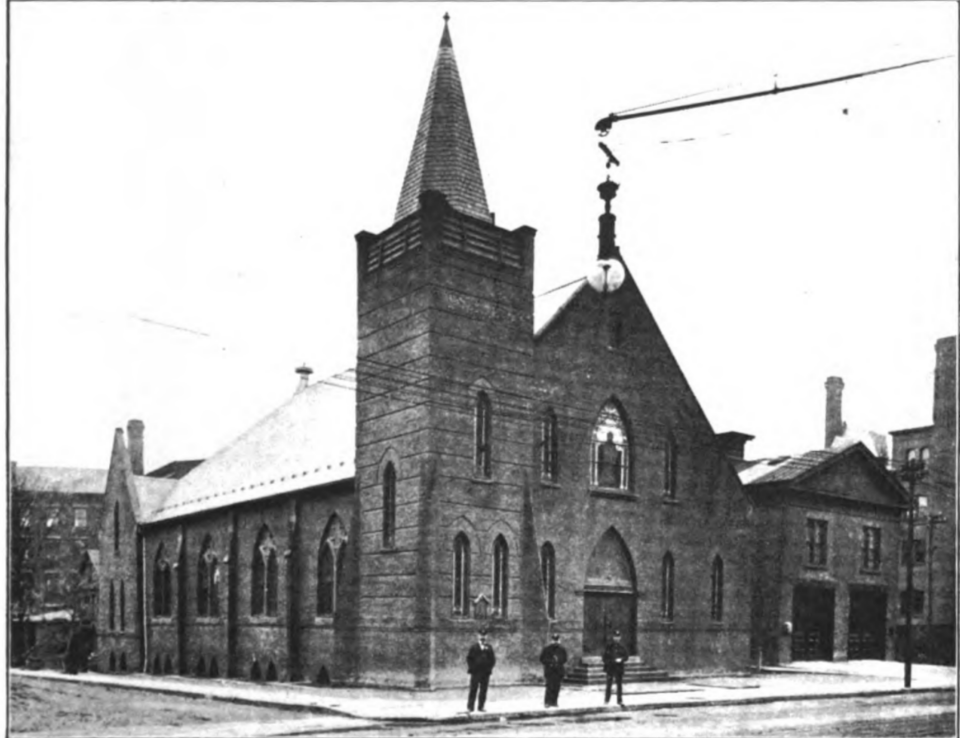
The Metropolitan A.M.E. Zion Church at its location on Pearl Street, Hartford, 1898. Colored American Magazine, May 1902
The North End became, then, a contemporary bellwether for residential and racial segregation because the mobility of African Americans was treated as a form of contagion, a rot to be prevented or contained. The 19th century had generated segregation that was meaningful at the level of streets and sometimes just a few blocks. Pockets of this kind remain in Hartford. Twentieth-century strategies around containment converged in housing and transportation policies. Racially restrictive covenants, urban renewal, public housing, and the building of the interstate highway system collectively reshaped where African Americans could live in Hartford and other American cities, pushing African Americans further into the North End. [See “The Federal Government and Redlining in Connecticut,” Summer 2019.]
In the last five years renewed attention to the legal and physical infrastructure of residential segregation has raised public consciousness about how and why America’s cities, including Hartford, became and remain deeply segregated. Scholarship on the subject spans academic and popular writing, old and new media platforms, and a range of interactive projects that take advantage of Geographic Information Systems (GIS).
Among the most compelling contributions exploring the link between racial segregation and housing policies are: Ta-Nehisi Coates’s “The Case for Reparations” (The Atlantic, June 2014), Keeanga-Yamahtta Taylor’s Race for Profit: How Banks and the Real Estate Industry Undermined Black Homeownership (University of North Carolina Press, 2019), Matthew Desmond’s, Evicted: Poverty and Profit in the American City (Crown, 2016), and Richard Rothstein’s The Color of Law: A Forgotten History of How Our Government Segregated America (Liveright, 2017). Digital mapping projects include LaDale Winling’s Mapping Inequality (dsl.richmond.edu/panorama/redlining/#loc=5/39.1/-94.58) and Brown University’s Urban Transition Project led by John Logan (s4.ad.brown.edu/Projects/UTP/index.htm). New groups like DesegregateCT capture the groundswell of advocacy that is attempting to build on the momentum of this kind of scholarship and public clamor for action.
This new scholarship revisits the origins of institutions like the Federal Housing Administration (FHA) and, later, the Veterans Administration (VA), which helped to shape an infrastructure of mortgage access, underwriting, and homebuilding that accommodated discriminatory practices. It documents how real estate agents lied about the availability of units for rent or sale and steered clients into or away from particular neighborhoods. Agents stoked fears of racial invasion or contagion with the explicit support of industry publications like the Annals of Real Estate Practice published by the National Association of Real Estate Boards. Developers accommodated racial preferences in their blueprints, sometimes as a condition of their financing and insurance arrangements. [See “How Segregation Happened in West Hartford,” Summer 2019.] Banks sometimes denied credit and mortgages, while insurance companies coded maps to delimit where people could purchase homes and how their homes would be valued. Public housing experiments like Bellevue Square initially welcomed as a way to address the shortfalls in housing supply, charted a middle ground by zoning units according to race and income.
Each American city produced its own vernacular forms of racial and residential segregation. What remained consistent, however, was the cast of characters and institutions that carved out the policies, procedures, and visions that informed where people could live. The collusion was systemic, encompassing the federal, state, and municipal governments, courts, banks, developers, employers, real estate agents, potential neighbors, and housing authorities.
Where people live can appear to be demographic accidents and individual choices that bear little relation to public policy or history. What the recent scholarship demonstrates, therefore, are the explicit and systemic connections between zoning, land use policies, urban planning, and residential segregation. Long after the passage of the Fair Housing Act in 1968 sought to eliminate these practices, the introduction of new mechanisms for the expansion of homeownership opportunities created new vulnerabilities, as underscored in Katherine O’Regan’s 2018 review of the 50th anniversary of this key legislation in Housing Policy Debate. New mortgage underwriting and insurance terms incorporated communities of color on predatory terms, according to Keeanga-Yamahtta Taylor. Moreover, the association between race, property values, and neighborhood character persisted as a shorthand way to maintain or justify racial segregation in every aspect of the housing market.
The prominence of the new scholarship serves as a form of a historical recognition, if not a reckoning. This accounting matters just as much for cities like Chicago or Los Angeles, which originated particularly vile housing policies, as for the cities that followed suit in domesticating these practices. The suite of digital mapping projects like Mapping Inequalityand the Urban Transition Project invite the public not only to explore its maps but also to download and make use of the underlying data that support the sites’ narratives.
My new digital humanities project in collaboration with James Kolb, Hartford Bound (hartfordbound.com), makes a similar gesture, with the goal of leveraging public and digital humanities methodologies to explore residential and racial segregation here. The project shows how Hartford’s built environment became a primer on the intertwining of race and space in both the 19th and 20th centuries. From the design of the interstate system that cut off the commercial business district from the African American community and its Home Owners Loan Corporation maps, to the location of public housing projects and railroads, the website maps how Hartford bears the imprint of 20th-century residential segregation. The site also maps how the AME Zion and Talcott Street (now Faith Congregational) churches relocated from downtown to the North End, mirroring the movement of the African American population. In mapping African American mobility, the site shows that the Bellevue Square project’s location in the immediate vicinity of the historic Cemetery Lane cluster was no mere coincidence. Hartford’s 20th–century history of segregation, its 19th-century antecedents, and its contemporary iterations, help to explain how the North End of Hartford became a predominantly African American community.
Fiona Vernal, lead scholar for 20 for 20: Innovation in Connecticut History, is associate professor of history and Africana studies at the University of Connecticut, and principal investigator of Hartford Bound. James Kolb, University of Connecticut, Class of 2020, is Hartford Bound’s co-principal investigator.
Explore!
Explore Hartford Bound at hartfordbound.com.
GO TO NEXT STORY
GO BACK TO FALL 2022 CONTENTS
