 By Nancy Finlay
(c) Connecticut Explored Inc. SPRING 2012
Subscribe/Buy the Issue!
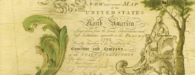
One of the treasures of The Connecticut Historical Society has long been A New and Correct Map of the United States of North America Layd Down from the Latest Observations and the Best Authorities Agreeable to the Peace of 1783. Not only is it the first map of the United States to be published in America, it is also the first map to be copyrighted in America and one of the first to show the flag of the young nation. It was printed and published in New Haven, Connecticut in 1784 and “Humbly Inscribed to the Governor and Company of the State of Connecticut by their Most Obedient and Very Humble Servant, Abel Buell.”
In December 2010, the copy of Abel Buell’s map belonging to the New Jersey Historical Society, one of only seven originals known to survive, sold at Christie’s New York for $2,098,500. That set a world record and made the Buell map the most expensive map ever sold at auction. The map was purchased by a private collector and is on long-term loan to the Library of Congress. Publicity accompanying the sale described the map as “a legendary rarity,” “one of the most coveted of all American maps,” and “one of the most important American cartographical documents.”
While the New Jersey Historical Society was selling its copy of the map, CHS was negotiating to lend its copy to Colonial Williamsburg for the exhibition More than Meets the Eye: Maps and Prints of Early America, on view from March of last year to this June. Thousands of people have seen the map, and last October, 98 historians, collectors, and museum professionals attended a symposium at Colonial Williamsburg to hear the map dealer Paul Cohen speak about “America’s First National Map.” Rarely has an old map generated so much interest.
For those not familiar with the history of cartography but very familiar with modern road maps and online resources, it might be difficult to understand what all the excitement has been about. Monumental in scale, Abel Buell’s map was a statement of national pride. It also reflected pride in his native Connecticut, whose western boundaries at the time, following the royal charter, extended beyond the Mississippi and included huge portions of Pennsylvania, Ohio, Indiana, and Illinois. [See “From the State Historian,” page 13.] There had, of course, been earlier maps showing the 13 colonies. Buell—who was an engraver, not a cartographer—based his map on the work of these earlier mapmakers, notably John Mitchell’s 1755 map, which was used by the negotiators of the Treaty of Paris that ended the Revolutionary War. Nor was Buell the first to perceive the need for a new map of the new nation. In Philadelphia, the geographer William McMurray had been trying since August 1783 to find funding to engrave and print his manuscript map of “The United States according to the Definitive Treaty of Peace.” But money was slow in coming, and Buell published his map first.
Buell was by all accounts a colorful character. John Warner Barber in the 1830s described him as “an uncommonly ingenious mechanic.” In the 1950s, Buell’s biographer Lawrence Wroth described him as “a restless, unstable, inventive genius.” Buell, born in Clinton, Connecticut in 1742, was apprenticed to a Madison silversmith and later married his master’s daughter. He appeared to be on the road to success, but then was apprehended for counterfeiting the colonial currency. He got off with a relatively light sentence in a day when his crime could carry the death penalty: One ear was cropped, he was branded on the forehead, and his property was confiscated and sold at auction.
In 1770, Buell relocated to New Haven, where he continued to work as a silversmith and jeweler and began experimenting with the founding of printing types and minting coins, this time legally. He also began engraving copper plates for printing. Since the technique for engraving on copper was essentially the same as that used by silversmiths for engraving on silver, Buell likely adapted quickly to this new trade. In 1775, sued for debt by New York printer James Rivington in connection with the printing of some of his engravings, Buell fled to Florida. He returned to New Haven in 1778, when it had become clear that Rivington, a Tory, stood little chance of successfully pursuing his claims in Connecticut courts.
Buell became part owner of a privateer and a packet-boat line in addition to his other business ventures. On March 31, 1784, he published an advertisement in the Connecticut Journal offering his now-famous map of the United States “to every patriotic gentleman and lover of geographical knowledge.” Despite its present-day fame, the map does not appear to have been a significant financial success. Its maker died a pauper in an New Haven almshouse in 1822.
Nancy Finlay was curator of graphics at The Connecticut Historical Society.
Explore!
The Connecticut Historical Society’s copy of Abel Buell’s $2 million map will be on view at the Historical Society following its return from Colonial Williamsburg this summer. For more information visit chs.org or call 860-236-5621. Additional maps from the collections of The Connecticut Historical Society may be viewed in Connecticut History Online at www.cthistoryonline.org.
Read more stories about Connecticut’s historic landscape and environment on our TOPICS page