by Walter W. Woodward
(c) Connecticut Explored Inc. Spring 2021
Subscribe/Buy the Issue!
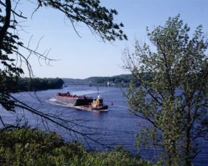
In an issue whose theme is “Environmental History,” no subject is more fitting than New England’s “Great River,” the Connecticut River, and its 7.2-million-acre watershed. Reaching from within 200 yards of the Canadian border in New Hampshire 410 miles to Long Island Sound at Old Saybrook, its watershed peaked by the Green Mountains to the west and the White Mountains to the east, the river that gave our state its name defines the environmental features most characteristic of New England. Here are the pine woods of the northeast kingdom, the hardscrabble hill and mill towns of Vermont and New Hampshire, the farm communities, artists’ colonies, and college towns of the Pioneer Valley, two of New England’s largest cities (Hartford and Springfield), and the historic tidal towns that border the estuary the Nature Conservancy has hailed as one of the world’s “last great places.”
What made the “Great River”––the early English settlers’ name for it––great, though, was not the variety of environments along its banks, nor the river’s tidal flow that reached 60 miles into the interior, the feature that led the Algonquian-speaking First Peoples to give it its lasting name Quinitukkut, meaning “the long tidal river.” Rather, the greatness of the Connecticut River derived from the energy of its mainstem and 38 major tributaries, a flow of freshwater greater than that of the Hudson River, a flow that led Adriaen Block, the Dutch trader and first known European to explore it, to call it the “Veroche” River––meaning fresh, as in fast running—as noted on the Figurative Map of Adriaen Block (New York Public Library).
A steady, and sometimes too-abundant, flow of water that caused the Connecticut River to overflow its banks and inundate the adjacent fields with nutrient-rich spring flood water led the region’s first inhabitants to build substantial communities and produce abundant harvests of corn, beans, and squash along its banks 1,000 years ago. That same flow of water led English incomers to build their first grist- and sawmills and seek their own harvests along its banks 600 years later, often on fields once farmed by the people they had dispossessed. To the settlers, accustomed to England’s “green and pleasant fields” (to quote William Blake), the annual spring floods, predictable in their occurrence but wildly variable in their magnitude, were a novel natural phenomenon that called for new words: freshet and intervale. Jeremy Belcher, the historian who coined these words in Volume 3 of his 1792 History of New Hampshire, defined freshet as “a river swollen by melted rain or snow, in the interior country, rising above its usual level, spreading over the adjacent lowlands, and rushing with an accelerated
current to the sea.” Intervale, he wrote, “is understood in all parts of New England to distinguish the lowland adjacent to fresh rivers, which is frequently overflowed by the freshets; and which is accounted some of our most valuable soil, because it is rendered permanently fertile by the bountiful hand of nature, without the labor of man.” The energy of the freshets drew the Puritan colonizers to the intervales. There they built their towns, and there they forged their histories.
Later, the same riverine energy would drive the millwheels and belts powering the factories that transformed New England into the marvel of the Industrial Revolution. Later still, that same flow of water would spin the turbines that produced the hydropower that lights the cities and runs the machines of a later century. Along the way, the river became heavily polluted and then, later, slowly and partially restored to its once pristine state. Through it all, the energy of the Connecticut River has been a main artery of our environment, culture, and energy.
Explore!
“Connecticut River: The First National Blueway Runs Through Connecticut,” Spring 2014
Listen!
Grating the Nutmeg Episode 106 – Part I: Steve Grant’s Legendary 1991 Source-to-Sea Connecticut River Journey
Part II
Read more stories about Connecticut’s environment and historic landscape on our TOPICS page.
GO TO NEXT STORY
GO BACK TO SPRING 2021 CONTENTS
Subscribe/Buy the Issue!
Sign up for our free bi-weekly e-newsletter

